Research Process
First we looked at the words in Dianne's song and then looked at a map of Westmere but the only Māori place name we found was Waitematā which is the Harbour at the end of Garnet Rd. The map showed the streams in our area, which are called Motion's Creek and Meola Creek and the lake, Western Springs.
Our teacher gave us two books to research these names, George Graham's, Māori Place Names of Auckland and High Hopes in Hard Times, a history of Grey Lynn and Westmere by Kaaren Hiyama. We looked up the names and decided to go for a walk around our area to follow the streams and find out about them.
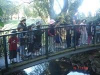
Here we are on the bridge at Western Springs looking down at Waiateao, Te Ao's Creek. The name was changed after Mr Motion built a flour mill in 1846 near where the zoo's elephant house stands.
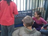
A few metres away we came to the Motion's Creek weir which controls the flow of water into the lake. We learnt that the original Māori name for the lake is Waiorea, the Waters of the Eel. We also learnt that the water in the lake comes from underground streams that flow here from Owairaka, Maungawhau and Te Tātua A Riukiuta. All these mountains' names have been changed to Pākehā ones. Owairaka, now called Mt Albert , is the maunga in our waiata.
Waiateao flows through the zoo and exits under Motion's Rd. This whole area was originally named Te Rehu. The Te Taou rangatira Apihai Te Kawau lived here with his people in the 1820s, when it was wetlands and mangroves.
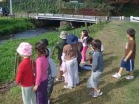
We followed Waiateao by Seddon Fields where our classmates play soccer. After Mr Motion closed his mill in 1875, other factories were set up and these all discharged untreated waste into the waterway. There was an abattoir, a tannery and a tallow and manure works, while the land above the creek became a rubbish dump.
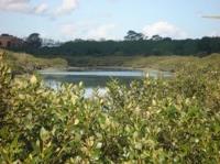
When Waiateao reaches Meola Rd it flows through a mangrove estuary and down to Meola Reef in the Waitemata Harbour.
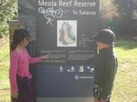
This ACC panel explains that the reef was formed by a 10km lava flow from the volcano named Te Tātua A Riukiuta. Read Te Tokaroa, for our retelling of the Maori purakau which explains the creation of this reef.
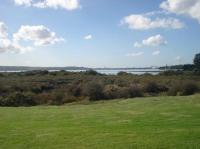
At low tide you can walk to the end of the reef. It's like being in the middle of the Waitematā. You can see the Harbour Bridge. Waiateao runs along the eastern side of the reef and Waititiko along the western side.
We now understood that our classroom Te Hononga O Ngā Wai is named after the joining of these two waterways with the Waitematā Harbour.
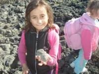
Taeao is holding a basalt rock from the reef. It has lots of small holes in it. These were air bubbles trapped in the rock when it cooled down, after the volcano erupted and the lava flowed to the sea.
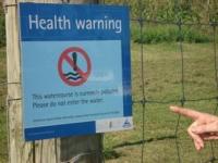
As we walked back along the banks of Waititiko we came upon this sign.
Aue taukuri e. We decided to find out what is causing the water pollution of these waterways that Whāea Dianne had written about in her song.


